Form 4 Geography (Juqraafi) national exam 2020 with answers
The 2020 Form 4 national exam paper for Form 4 Geography (Juqraafi), question by question. Take it timed like the real exam, then see the answer and explanation to every question.
- 43 questions, 100 marks
- 120 minutes
Take this paper
120 minutes, 100 marks. Multiple choice is marked for you; you mark your written answers against the marking points.
A free account is needed to start, so your answers and results are saved.
Instructions to candidates
Write all answers on the answer booklet. Write legibly in dark blue pen only. Answer all questions as provided in the question paper. The paper is printed in English and Arabic.
Part one (Multiple Choice) (40 marks)
Write the correct answer in the answer booklet.
- 12 marks
Somalia has a land area of about:
- A.637,657 km^2
- B.677,657 km^2
- C.667,547 km^2
- D.697,657 km^2
- 22 marks
The source of River Jubbah and Shebelle is:
- A.Kenyan highlands
- B.Ethiopian highlands
- C.Djibouti highlands
- D.Uganda highlands
- 32 marks
Maize was first grown in:
- A.Argentina
- B.Colombia
- C.Mexico
- D.Brazil
- 42 marks
Which one of the following is a land locked country:
- A.Somalia
- B.Djibouti
- C.Eritrea
- D.Rwanda
- 52 marks
Before the invention of the steam engine, sea vessels used:
- A.Sun power
- B.Flowing water
- C.Water power
- D.Wind power
- 62 marks
The first air route was opened between:
- A.London and Paris
- B.Berlin and Roma
- C.Paris and Berlin
- D.Moscow and London
- 72 marks
The Suez Canal connects the:
- A.Dead sea and Black sea
- B.Mediterranean sea and Red sea
- C.Red sea and Black sea
- D.Arabian sea and Gulf of Eden
- 82 marks
The least common type of migration is:
- A.Rural to Rural
- B.Rural to Urban
- C.Urban to Rural
- D.Urban to Urban
- 92 marks
The sun overheads at midday along the tropic of Cancer:
- A.23rd September
- B.22nd December
- C.21st March
- D.21st June
- 102 marks
The largest Ocean of the world is:
- A.Arctic Ocean
- B.Indian Ocean
- C.Atlantic Ocean
- D.Pacific Ocean
- 112 marks
The largest lake in Africa is:
- A.Victoria
- B.Albert
- C.Malawi
- D.Turkana
- 122 marks
Which of the following regions of Somalia has NO coast line?
- A.Bokool
- B.Mudug
- C.Galgadud
- D.Middle Shabelle
- 132 marks
The highest mountain in Africa is:
- A.Mount Kenya
- B.Elgon
- C.Kilimanjaro
- D.Ras-dashan
- 142 marks
If the time in Cairo (30^0 E) is 9:00am, what is the time in Mogadishu (45^0E)?
- A.10:00am
- B.8:00am
- C.7:00am
- D.6:00am
- 152 marks
Which of the following regions river Jubba does NOT flow through?
- A.Lower Jubba
- B.Middle Jubba
- C.Gedo
- D.Middle Shabelle
- 162 marks
The most important export of Somalia is:
- A.Banana
- B.Livestock
- C.Fruits
- D.Fish
- 172 marks
The following fishing method is seasonal?
- A.Traps
- B.Seining
- C.Barrier
- D.Gillnet
- 182 marks
The longest river in Africa is
- A.Niger
- B.Nile
- C.Congo
- D.Jubba
- 192 marks
The summer monsoon rain called "Xagayo" is common in the region of
- A.Sool
- B.Bay
- C.Bakol
- D.Banadir
- 202 marks
The largest desert in Africa is
- A.Arabian
- B.Namibian
- C.Kalahari
- D.Sahara
Part two: Short answer questions
Answer the flowing questions (30 marks)
- B12 marks
Where does River Jubba flow into the Indian Ocean?
- B22 marks
State two regions that River Shabelle flows through?
- B32 marks
The two main rainy seasons in Somalia are
- B42 marks
What are the types of agriculture?
- B52 marks
Define the term "fisheries"?
- B62 marks
List down two basic types of fish communities?
- B72 marks
Mention two major types of inland fishing grounds?
- B82 marks
Define the term "energy"?
- B92 marks
Industrialization has negative effects on environment. State two effects.
- B102 marks
Write down any two major sea routes?
- B112 marks
When is the sun overhead at midday along the equator?
- B122 marks
There are types population census. List two of them.
- B132 marks
Which is the most easterly country in Africa?
- B142 marks
Define the term "internal migration"?
- B152 marks
What does mortality refer to?
Part three: Essay questions (30 marks)
Answer all the questions in this part.
- C14 marks
Somalia is a land of rolling plains. Explain.
- C22 marks
Describe two fishing methods?
- C34 marks
Renewable and non-renewable are the two main sources of energy. Compare and contrast?
- C44 marks
Differentiate between Industry and Industrialization?
- C52 marks
Flooding is a common phenomenon in our country every year. Discuss how this calamity can be prevented.
- C64 marks
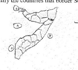
Identify the countries that border Somalia in the parts labeled A to D in the map below?
- C74 marks
There are some severe circumstances which force people to migrate from Somalia. Explain two causes?
- C82 marks
People use forests for many purposes causing desertification in our country. Evaluate how we can discourage people from these practices
Paper set by the Federal Ministry of Education, Culture and Higher Education (MoECHE), Somalia. Shared free of charge to help students prepare. The answers and explanations are written by Sheerxirfad teachers.